Marine Ecosystems
Posidonia Oceanica
MONITORING AND CONSERVATION
Marine Ecosystems
Posidonia Oceanica
MAPPING AND MONITORING PO MEADOWS
Sentinel-2 (MSI) provides global, regular and repeated coverage of inland, coastal and open sea waters under cloud-free sky. One of the many applications of Sentinel-2 data is for marine ecosystem monitoring in shallow coastal waters.
In particular, Quasar can provide customized Sentinel image services specifically designed to map the meadows of Posidonia oceanica in the Mediterranean Sea. Posidonia oceanica is a seagrass species that is endemic to the Mediterranean Sea, and it constitutes one of the most important ecosystems of the sea. Posidonia is one of the main sources of oxygen in the sea and it is considered to be a good bioindicator of the quality of the water.
S2 routinely collects large amounts of images which are made freely available. The vast amounts of data produced by the constellation of satellites are a great opportunity to develop systems for marine ecosystem monitoring in shallow coastal waters. To become fully operational, these processing systems must be entirely automatic with a controlled level of reliability and robustness.
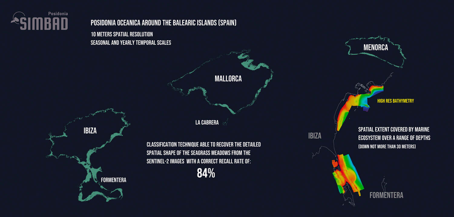
Quasar’s system provides Posidonia oceanica maps with a 10 m spatial resolution and at different temporal scales, being the recommended one, but not limited to, yearly cartography. A seasonal and yearly scale cartography should be enough for decision-making on conservation measures. Our classification technique is able to recover from S2 images the detailed spatial shape of the seagrass meadows with a correct recall rate of 84% for Posidonia pixels. These results prove accurate up to depths close to 30 meters in depth. Our classification method can provide an extremely cost-effective way to monitor variations of Posidonia oceanica meadows using the S2 archive (2015-present). Another advantage of the system designed is the ability to replicate results.
See PDF

SENTINEL-2
13 spectral bands: four of them at 10 m spatial resolution
5 day revisit at equator


Bioindicator of the quality of the coastal waters
Scientific name: Posidonia Oceanica.
Seagrass species that is endemic to the Mediterranean Sea.
Forms underwater meadows.
Covers an area of 3% of the basin.
Lives between 1 and 30 m deep in clear waters, it can live up to.
40 m deep.
Releases up to 20 liters of oxygen per day and per m2 of meadow.
Products | Applications | Services
Marine Ecosystems Products
- Posidonia oceanica maps (shapefiles) at a 10 m spatial resolution
- Posidonia oceanica maps (shapefiles) at different temporal scales, like yearly or seasonal
Marine Ecosystems Applications
The Marine Ecosystems Products can be used for different applications. Some examples are:
- Time-series analysis of Posidonia oceanica cartography for the provision of evidence to support the development of better coastal laws and regulations addressing identified issues
- Allow for spatial and temporal evolution studies to monitor degradation as a result of natural causes or coastal development
- Evaluation of ecosystem status by comparing the before and after natural events or coastal human activity, like infrastructure development
- Determine the spatial extent covered by marine ecosystem over a range of depths (down not more than 30 meters)
- Distinguish different seagrass species, in the Mediterranean Sea, mainly Posidonia oceanica and Cymodocea nodosa
- Cross-correlation of marine ecosystems with maritime activities (vessel traffic, tourism, fishing, etc …), like, the location of maritime objects extracted from Sentinel-1 SAR data or external sources of data (ex. AIS data)
Marine Ecosystems Services
- Dedicated tailor-made solutions for satellite and model-based Marine Ecosystems applications
- Participation in R&D projects at national and European levels
- Consulting services about Sentinel-2 and applications
- Support the integration of Sentinel-2 data into your solution
- Support the integration of Copernicus Marine Service products into your solution
Maritime Ecosystems | Application Examples
Marine Ecosystems Spatial Coverage
PO cartography allows to estimate the spatial coverage of marine ecosystems and stablish their correlation with maritime activities like, vessel traffic, tourism, fishing, etc...
Spatial studies can support the development of better coastal laws and aid in the decisión making progress on conservation measures.
Marine Ecosystems Temporal Coverage
Temporal evolution studies of marine ecosystems can be used to monitor ecosystem degradation as a result of natural causes or coastal development.
It is possible to evaluate the status of the ecosystem by comparing the before and after natural events or anthropogenic activities.
Boat Presure Over Marine Ecosystems
S1 boat detections can be used in combination with meadow location to assess boat pressure over marine ecosystems.
The temporal analysis of these pressure points can be used to monitor seasonal boat activity and help in putting measures in place to protect marine ecosystems.


