There is currently a wide range of passive and active sensors located both in situ as well as remotely, mounted on land, water, aerial or satellite platforms to monitor the conditions of the vegetation. Remote sensing from satellite platforms uses both active and passive sensors for data acquisition, capturing data from one or multiple parts of the electromagnetic spectrum.
The information contained in these data sets can only be exploited using advanced image and signal processing techniques, which frequently makes its access difficult for people, businesses, and institutions.
Among the multiple applications of remote sensing, there are numerous uses for agriculture, such as crop type identification, land cover and land use mapping, monitoring change and phenology, identification of pest and disease, crop stress and droughts, yield forecasts, phenotyping, soil moisture, evapotranspiration, etc.
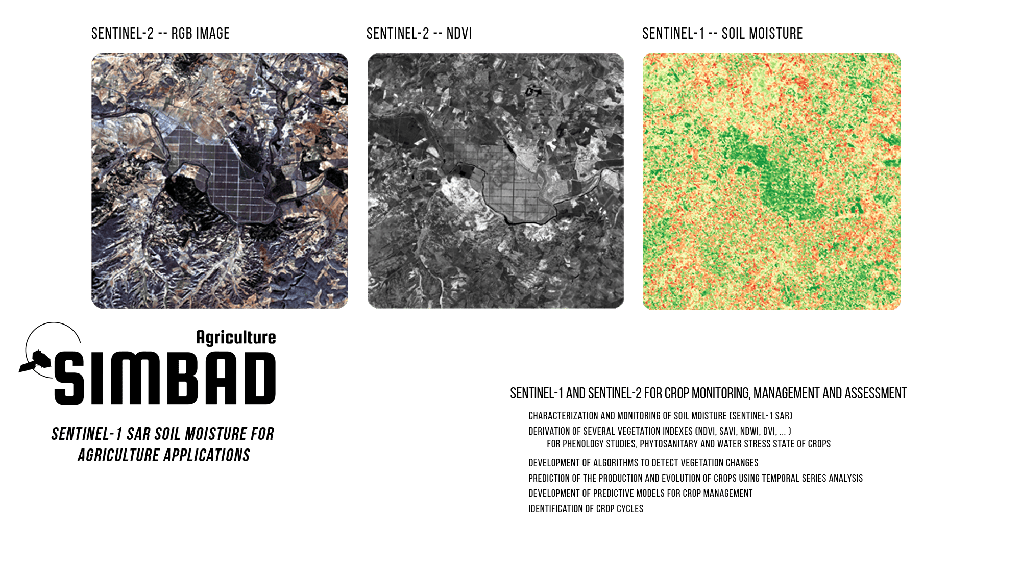
Sentinel-1 (S1) and Sentinel-2 (S2) provide global, regular and repeated coverage of land regions. Among the many applications of S1 Synthetic Aperture Radar (SAR) and S2 optical data, Precision Agriculture can benefit from both missions used in conjunction to maximize their output. While optical data from S2 are intuitive and related with vegetation vigor status, S1 SAR has the advantage of operating under cloud cover or lack of illumination, acquiring useful data during day and night under all weather conditions.
Sentinel-1 and Sentinel-2 routinely collect large amounts of images which are made freely available. The vast amounts of data produced by the two constellations of satellites are a great opportunity to develop systems for Precision Agriculture. To become fully operational, these processing systems must be entirely automatic with a controlled level of reliability and robustness
See PDF
SENTINEL-1
Synthetic Aperture Radar (SAR) Wave aquisition mode 20km by 20km at 5m spatial resolution
6 day revisit at equator
SENTINEL-2
Multispectral Instrument (MSI) 13 spectral bands: four of them at 10 m spatial resolution
5 day revisit at equator
In the current context of global change, effective monitoring of processes on the Earth’s surface is essential. Fortunately, this need for monitoring and prediction has been accompanied by a great availability of information and computational capacity. One of the most important factors to consider regarding the characterization of agricultural soil is soil moisture. Radar remote sensing from satellite images has demonstrated its ability to retrieve soil moisture at spatial scales spanning tens of kilometers in an operational manner.
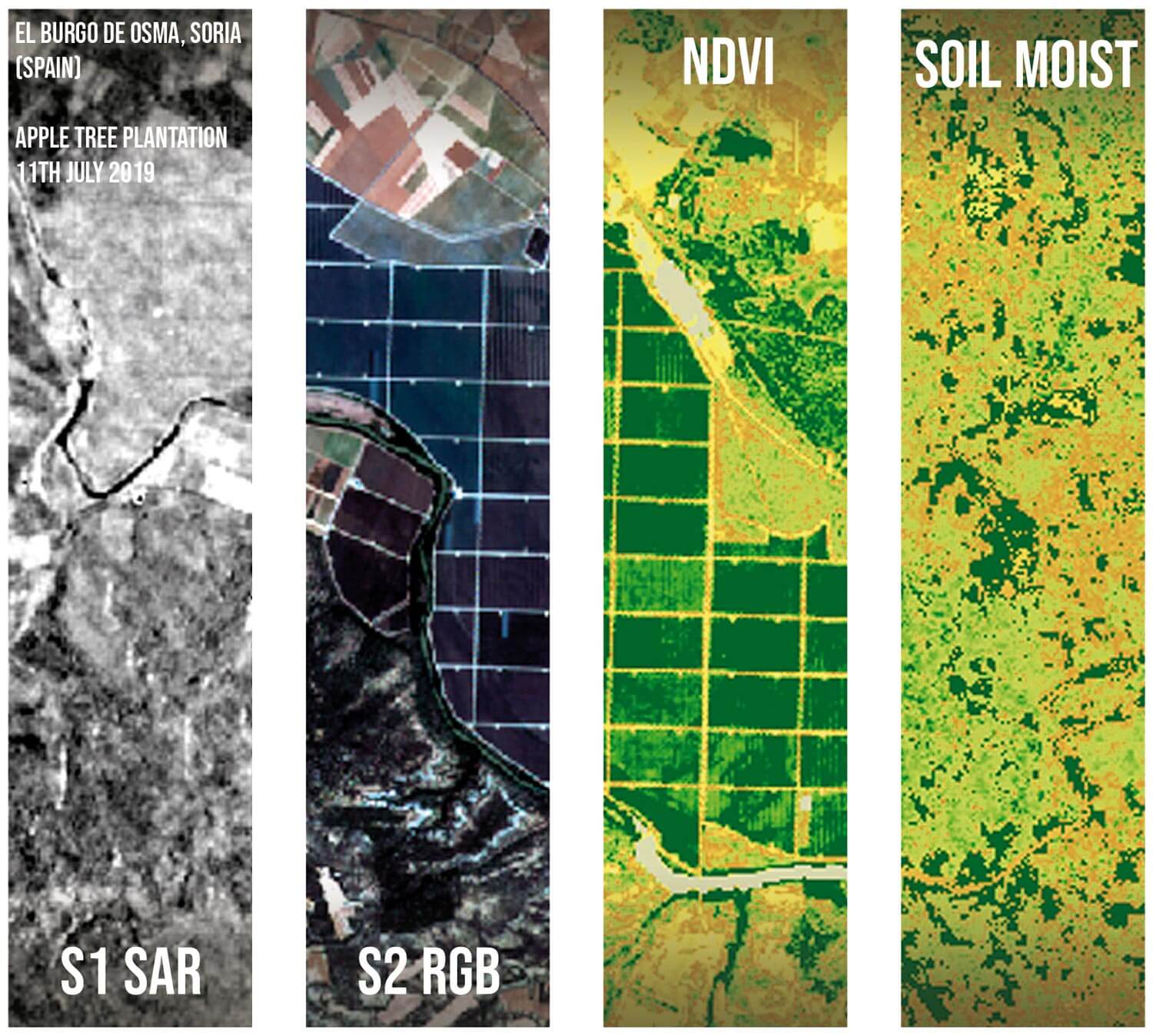
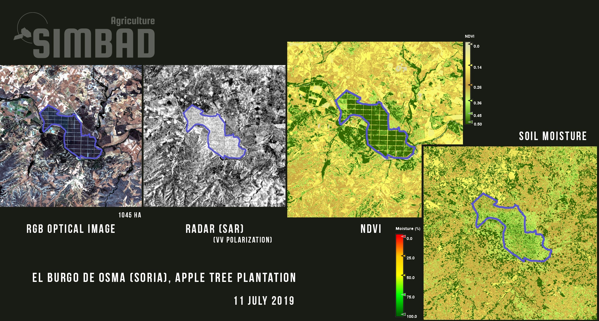
Quasar has deviced the methodology to derive soil moisture using radar and optical data from the Sentinel-1 and Sentinel-2 satellites. In general terms, the signal received by the radar (backscattering coefficient) can be modeled as the sum of the bare soil signal attenuated by vegetation effects, plus the vegetation signal. For the same vegetation index, such as NDVI (or SAVI), the vegetation effect can be reduced if the radar signals are compared for two different dates, i.e., for the same structure and vegetation cover, temporal changes in the radar signal can be considered to be due to variations in soil moisture. To achieve this, the use of different vegetation indices has been analyzed to model the vegetation cover and, therefore, its contribution to the radar backscattering coefficient, in addition to validating the results using in-situ data. The final service provides soil moisture values from Sentinel-1 and Sentinel-2 data with a resolution of 10 meters and a temporal coverage of around a week.
Products | Applications | Services
Agriculture Monitoring Products
Vegetation indices (NDVI, SAVI, NDWI, DVI, …)
Soil moisture maps
Crop classification maps
Crop rotation maps
Vegetation parameters
Time series of indices and parameters
On request, Quasar provides user-based monitoring systems of key indicators by developing user-adapted algorithms for the detection and warning of vegetation changes. These systems, allow users to accurately assess the state of the crops and define the most appropriate actions for the mitigation of the impacts to maximize performance with the lowest environmental impact.
Agriculture Monitoring Applications
The Agriculture Monitoring products can be used for different applications. Some example applications are:
Remote crop monitoring with high spatial detail (10 m)
Vegetation indices, when used correctly, can provide information on the phytosanitary status of the vegetation, phenology, water stress, etc …
Estimations of parameters such as height, volume and biomass using bistatic interferometry techniques with data from commercial satellites
Analysis of crop dynamics with vegetation indices using time series (since 2017)
Identification of crop rotation
Generation of anomalies and prediction models for crop management
Generation of operational models to correlate phenological cycle with production
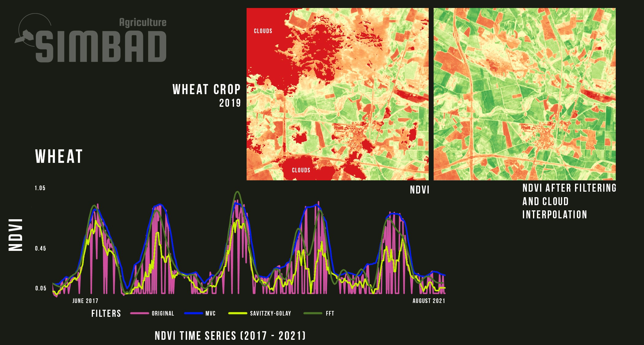
Development and application of different time series filtering, which when applied to an image can improve its quality
Monitoring key indicators, including, change and phenology detection, pest and disease identification, crop stress and droughts, and soil moisture and evapotranspiration
Agriculture Monitoring Services
Dedicated tailor-made solutions for Sentinel-1 SAR and Sentinel-2 optical applications
Consulting services about Sentinel-1 and Sentinel-2 data, products and applications
Support the integration of Sentinel-1 and Sentinel-2 data into your solution
Support the integration of auxiliary non-EO data into your EO solution
Participation in R&D projects at national and European levels with experience leading projects and working within large collaborations
S1 SAR and S2 imaging, can be combined to recover soil moisture for agriculture applications.
An operational system for soil moisture mapping at the high spatial resolution offered by S1 is important for agriculture applications, management and risk assessment. The approach can serve as a solution that works over bare soils, as well as soils with vegetation cover.
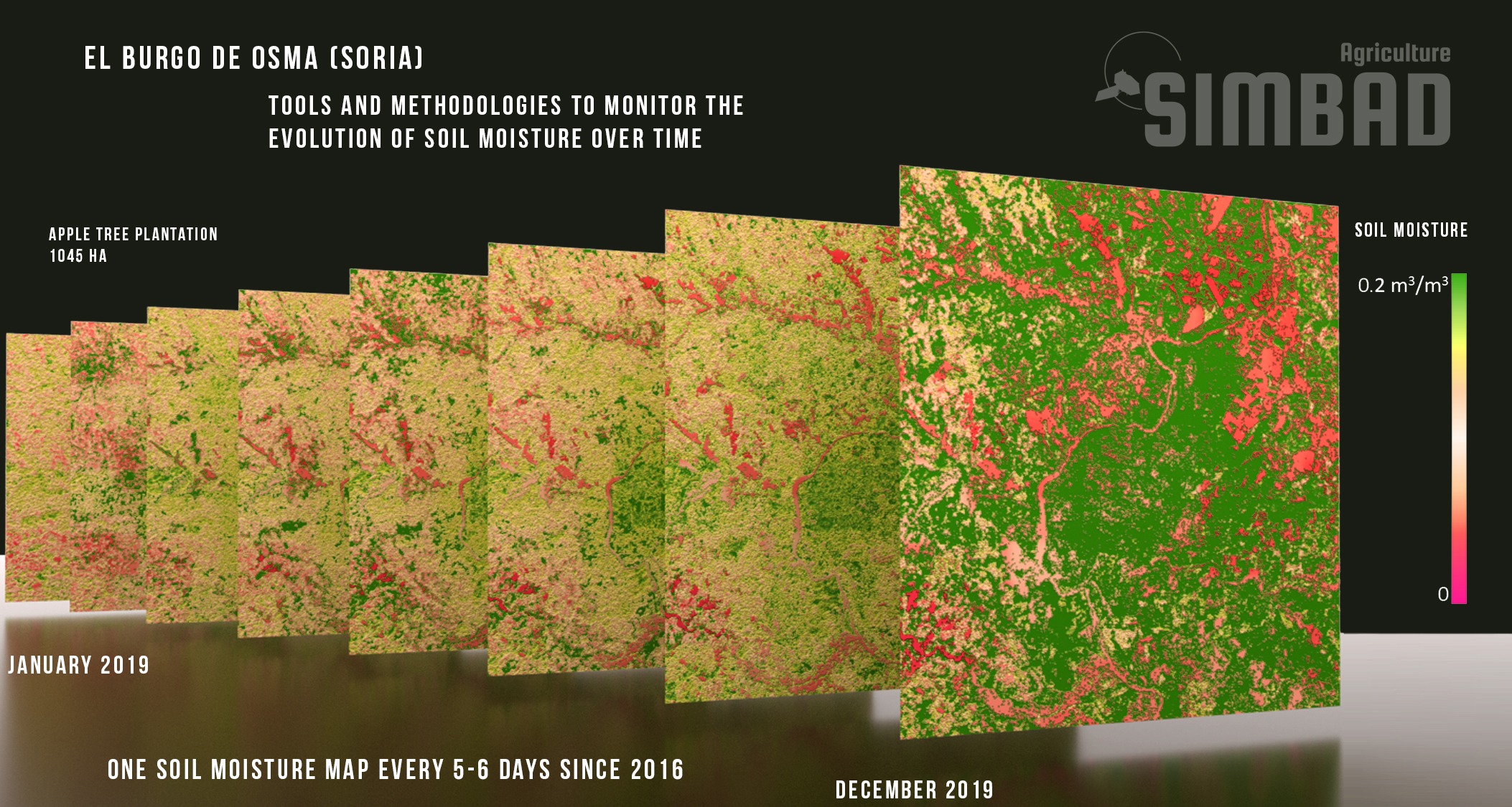
Soil Moisture Monitoring
One of the most important factors in the characterization of the properties of the agricultural soil is its water content and its evolution over time.
For the same vegetation cover and structure, one can assume that changes in the radar signal are due to changes in the soil moisture.
Time Series for Crop Evaluation
Analysis of crop dynamics with vegetation indexes using time series can provide important information about crop rotation.
Different filters applied to the time series can be developed and used to, for example, obtain cleaner images and improve their quality, as well as, to develop anomalies and prediction models.
This website uses cookies so that we can provide you with the best user experience possible. Cookie information is stored in your browser and performs functions such as recognising you when you return to our website and helping our team to understand which sections of the website you find most interesting and useful.
Strictly Necessary Cookies
Strictly Necessary Cookie should be enabled at all times so that we can save your preferences for cookie settings.
If you disable this cookie, we will not be able to save your preferences. This means that every time you visit this website you will need to enable or disable cookies again.