Sentinel-2 (MSI) and Sentinel-3 (OLCI) provide global, regular and repeated coverage of inland, coastal and open sea waters under cloud-free sky. One of the many applications of both these satellites data is for water quality monitoring, making it suitable to measure and monitor different water quality parameters i.e., Chlorophyll (Chl-a) as a proxy of primary productivity, Turbidity (T), Total Suspended Matter (TSM), Coloured Dissolved Organic Matter (CDOM), and Sea Surface Temperature (SST).
By measuring different physical and chemical parameters of the lakes, rivers, coastal areas, estuaries, and open sea waters, it is possible to monitor the water quality status as well as the eutrophication of the respective water bodies, assess ecosystem productivity, and identify, for example, potential sites for fish farming. Also, turbidity and sediment load measurements are useful in dealing with coastal problems like delta growth and retreat, beach erosion, and modification of harbor basins.
S2 and S3 routinely collects large amounts of images which are made freely available. The vast amounts of data produced by the constellation of satellites are a great opportunity to develop systems for Water Quality Monitoring.
To become fully operational, these processing systems must be entirely automatic with a controlled level of reliability and robustness.
SIMBAD can provide current and time series maps of different water quality estimators for a wide range of areas, including European and Global coastal and open seawaters. SIMBAD also provides water quality monitoring systems by developing region-specific algorithms.
See PDF
SENTINEL-2
13 spectral bands: four of them at 10 m spatial resolution
5 day revisit at equator
SENTINEL-3
Sea and Land Surface Temperature Radiometer (SLSTR)
Ocean and Land Colour Instrument (OLCI)
Synthetic Aperture Radar Altimeter (SRAL)
SLSTR, ku and c band with a 300 m spatial resolution
OLCI, a 300 m spatial resolution and 21 spectral bands
SRAL, sar altimeter and microwave radiometer
Satellite remote sensing allows to measure:
Chlorophyll Concentrations : proxy of biomass or ecosystem productivity as well as the indicator of water quality, fish farming, eutrophication and human consumption (max resolution 10 m)
Turbidity or Suspended Matters : essential in dealing with coastal problems like delta growth and retreat, beach erosion, water quality monitoring and modification of harbour basins (max resolution 10 m)
Sea Surface Temperature, available Solar Radiation to the water body : help to understand the status of productivity in the aquatic ecosystem (max resolution 1 km, accuracy of 0,3K)
Ocean Current Circulations or Wind Velocity components : help to understand the dispersion of suspended matter, chlorophyll as well as any kind of spillage
SIMBAD incorporates,
Standard products and generic algorithms are available. It is possible to develop regional algorithms to monitor chlorophyll concentrations and turbidity. For this, the algorithms have to be calibrated and validated.
These algorithms allow to study the temporal evolution of these parameters:
7-days mean
15-days mean
monthly mean
seasonal mean and yearly mean
About these algorithms:
Cloudless days required -> temporal resolution: 1 image per week
Max spatial resolution 10 m (Sentinel-2), higher resolution can be possible using commercial satellite imagery
Temporal resolution of 3-4 days passage (Sentinel-2 ), higher resolution can be possible using commercial satellite imagery
Products | Applications | Services
Water Quality Monitoring Products
Water quality parameter maps.
Maps of Harmful Algae Blooms (HABs)
Maps of Chlorophyll-a (Chl-a) concentrations
Maps of Total Suspended Matter (TSM) concentrations
Maps of Turbidity level
Maps of Coloured Dissolved Organic Matter (CDOM) concentrations
Maps of Sea Surface Temperature (SST)
Quasar provides Water Quality Monitoring services for the above-mentioned parameters. On special requests or demands, Quasar also provides region-based monitoring systems by developing specific regional algorithms.
Besides, Quasar also provides a package of satellite and model derived environmental forces data i.e., Salinity, Ocean Currents, Photosynthetic Active Radiation (PAR), and wind mixing index (WMI), along with the water quality products (HABs, Chl-a, TSM, Turbidity, and SST), providing useful information for decision making in the management of coastal natural resources.
Water Quality Monitoring Applications
Different Water Quality Monitoring products can be used for different applications. Some example applications are:
Harmful Algae Bloom (HABs) monitoring
Eutrophication monitoring
Ecosystem monitoring
Aquaculture site selection
Identification of delta growth and retreat
Identification of beach erosion
Sediment load estimation
Water quality monitoring
Water Quality Monitoring Services
Dedicated tailor-made solutions for satellite and model-based Water Quality applications
Consulting services about Sentinel-2, Sentinel-3 and their applications
Support the integration of Sentinel-2 and Sentinel-3 data into your solution
Support the integration of Copernicus Marine Service products into your solution
Participation in R&D projects at national and European levels with experience leading projects and working within large collaborations
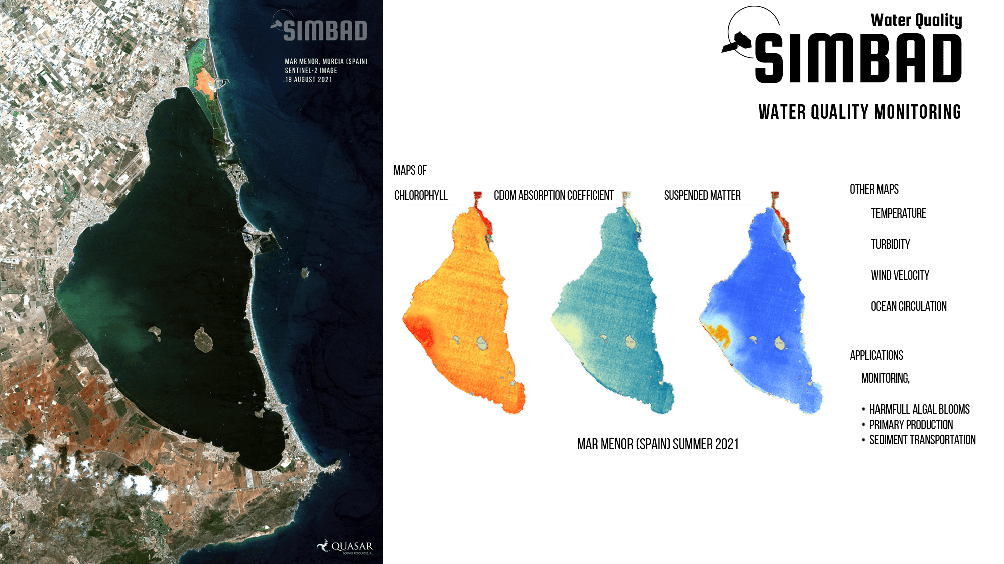
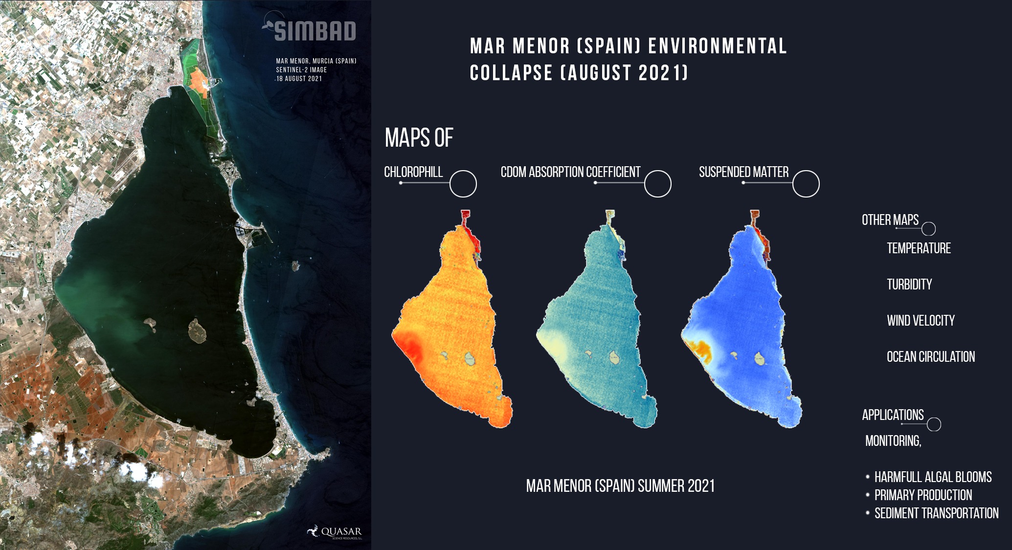
S2 water quality maps of Chl-a, CDOM, and TSM at 10 metre spatial resolution.
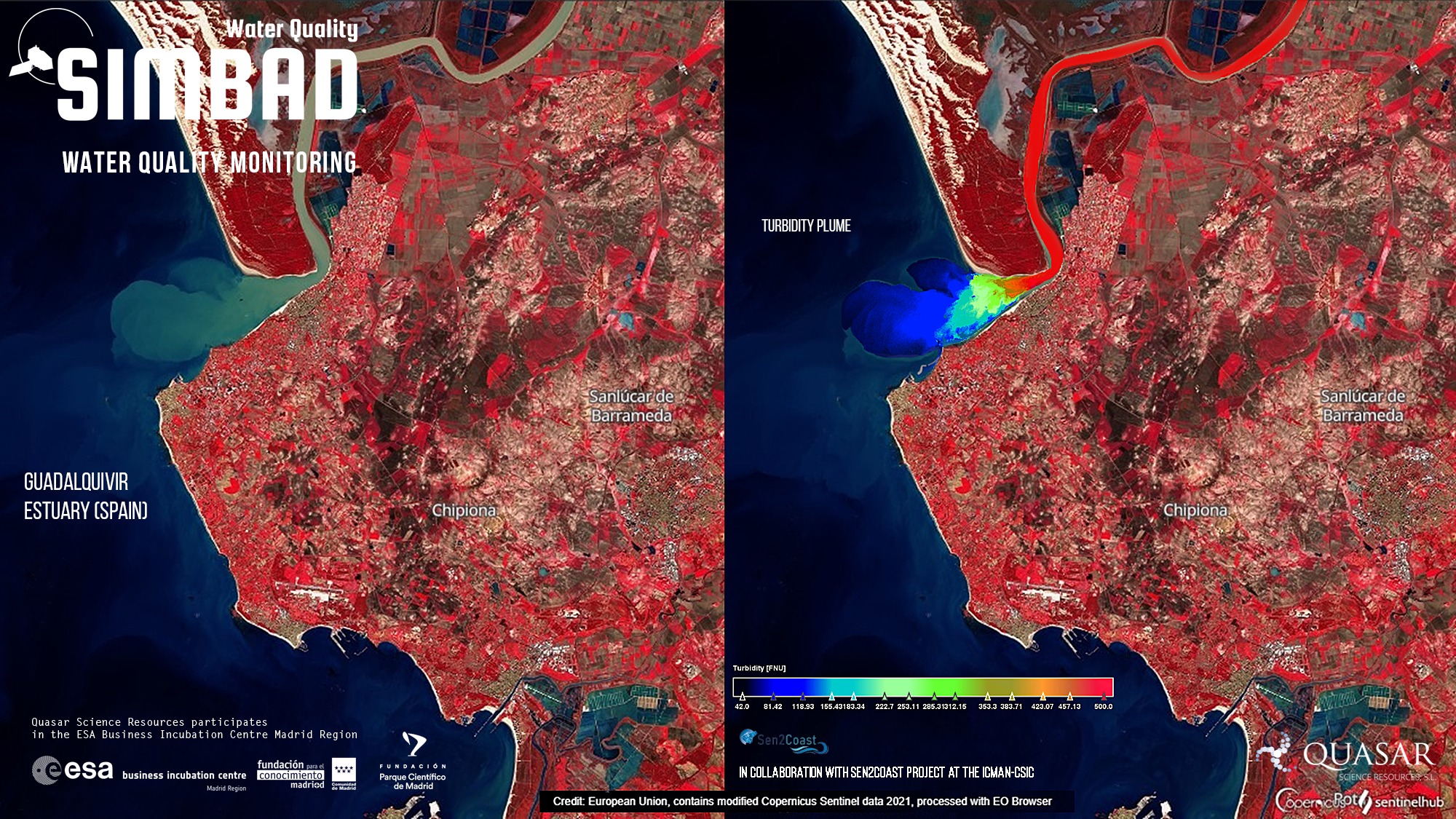
Water quality maps help to identify point sources of pollution. It also provides the spatial and temporal distribution of the pollutants which are not readily available from in-situ measurements. These type of information is helpful for accurate assessment or management of the water bodies.
Turbidity and Algal Bloom
Prolonged turbidity episodes can cause hypoxia and inhibit the growth of phytoplankton in coastal regions, thus negatively affecting the productivity of the aquatic ecosystem. Examining
the turbidity levels can assists coastal managers and policy makers to control the challenging issue of water quality monitoring.
HABs can represent a potential health risk.
Aquaculture Site Selection
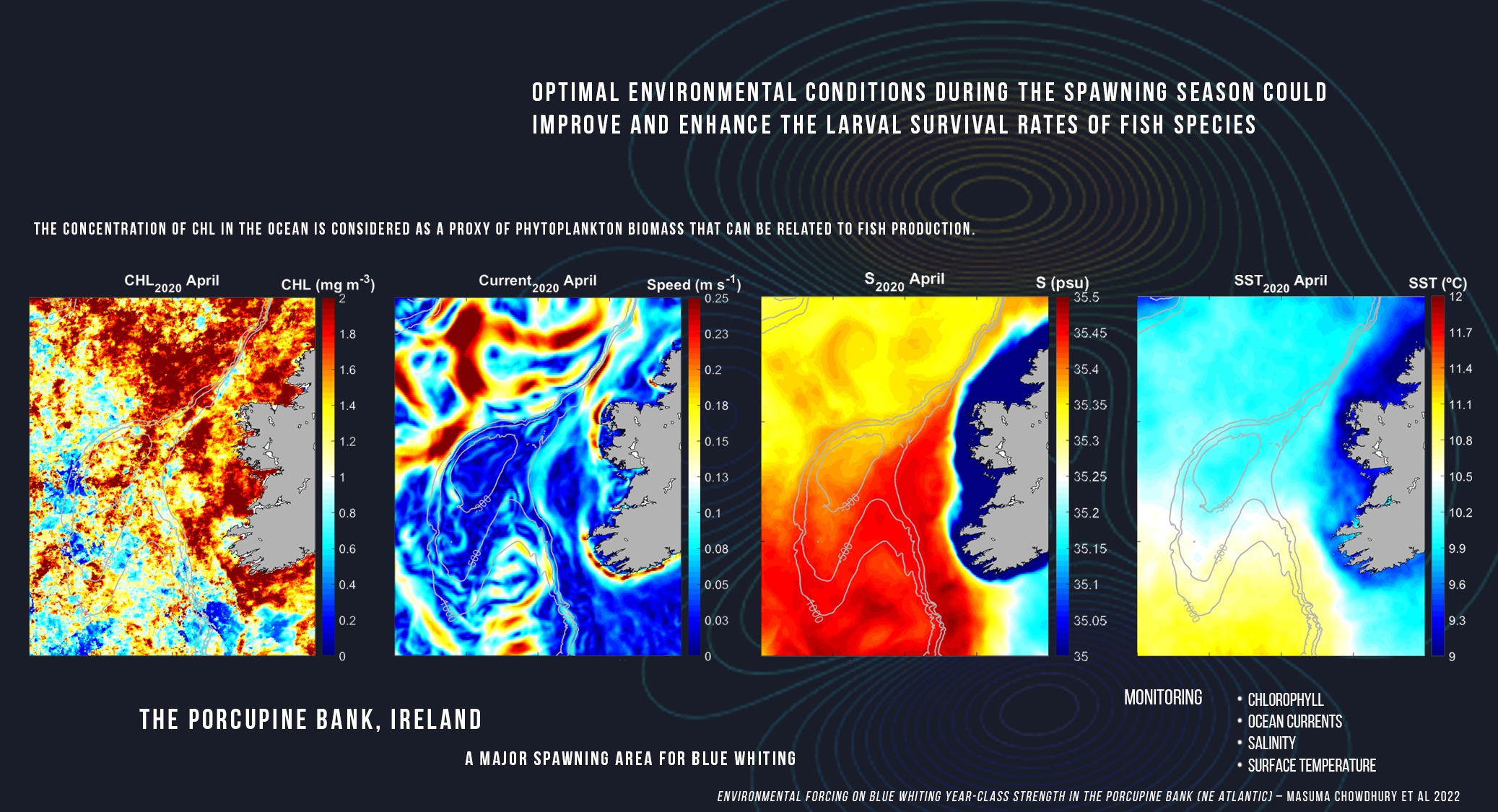
By examining different physical and biochemical parameters derived from a combination of satellite products, it is possible to identify potential regions for specific fish farming.
Different products from a combination of different satellites and modeled data can be used as a proxy of ecosystem productivity.
This website uses cookies so that we can provide you with the best user experience possible. Cookie information is stored in your browser and performs functions such as recognising you when you return to our website and helping our team to understand which sections of the website you find most interesting and useful.
Strictly Necessary Cookies
Strictly Necessary Cookie should be enabled at all times so that we can save your preferences for cookie settings.
If you disable this cookie, we will not be able to save your preferences. This means that every time you visit this website you will need to enable or disable cookies again.